
MEDEEN-XR

Qatar-hosted XR planning intelligence
for smarter urban decisions
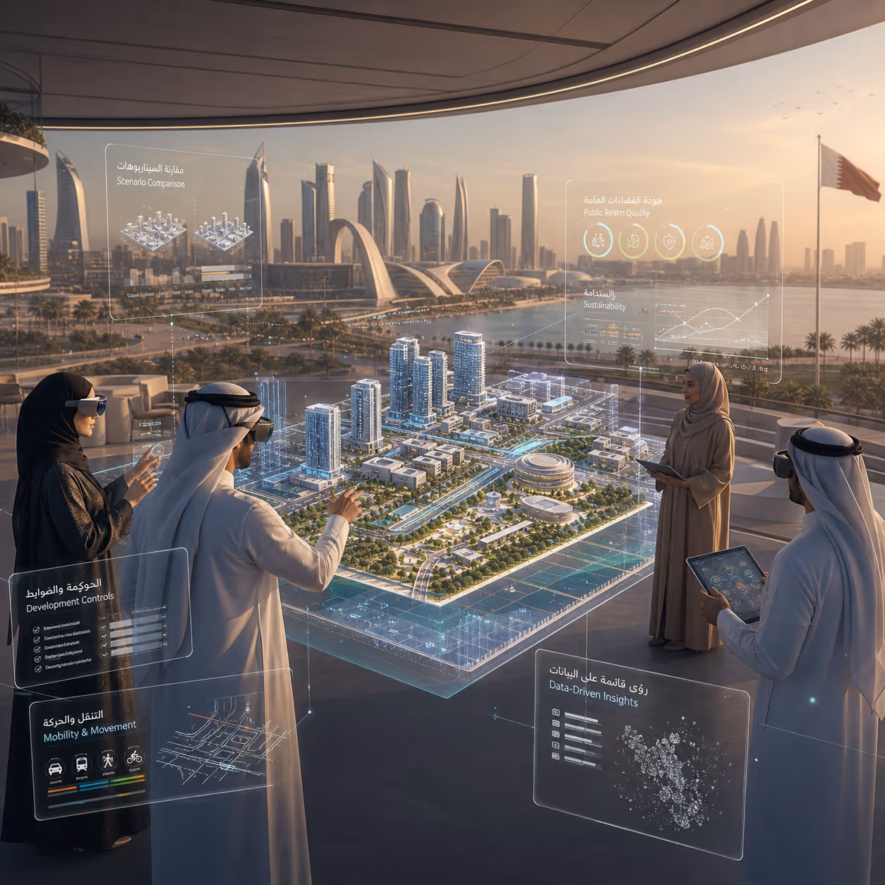
MEDEEN-XR is an immersive urban planning platform that transforms spatial data, planning rules, and urban analytics into interactive 3D experiences. Built for Qatar’s planning ecosystem, the platform enables planners, public agencies, developers, and stakeholders to explore urban districts, compare planning scenarios, and understand development pressure through explainable XR visualizations.
The Phase I proof-of-concept focuses on a pilot capture core of at least 5,000 m², converting spatial capture and sourced planning data into streamable 3D content and validating it inside a prototype application. The project roadmap includes a Qatar-hosted 3D base map, interactive walkthroughs, bilingual Arabic/English interfaces, planning scenario overlays, and user testing with more than 20 participants to validate TRL4 feasibility.

Why MEDEEN-XR?
MEDEEN-XR brings these layers together into one interactive environment, allowing stakeholders to see how planning choices affect streets, buildings, public spaces, mobility, density, services, and environmental quality.
Qatar-Hosted 3D Urban Base Map
MEDEEN-XR creates a streamable 3D foundation for a defined pilot area, allowing stakeholders to walk through the district in an interactive environment rather than reviewing static drawings or disconnected datasets.
Planning Scenario Visualization
MEDEEN-XR allows planners to switch between “what-if” planning scenarios and visualize their effects directly inside the 3D urban environment.
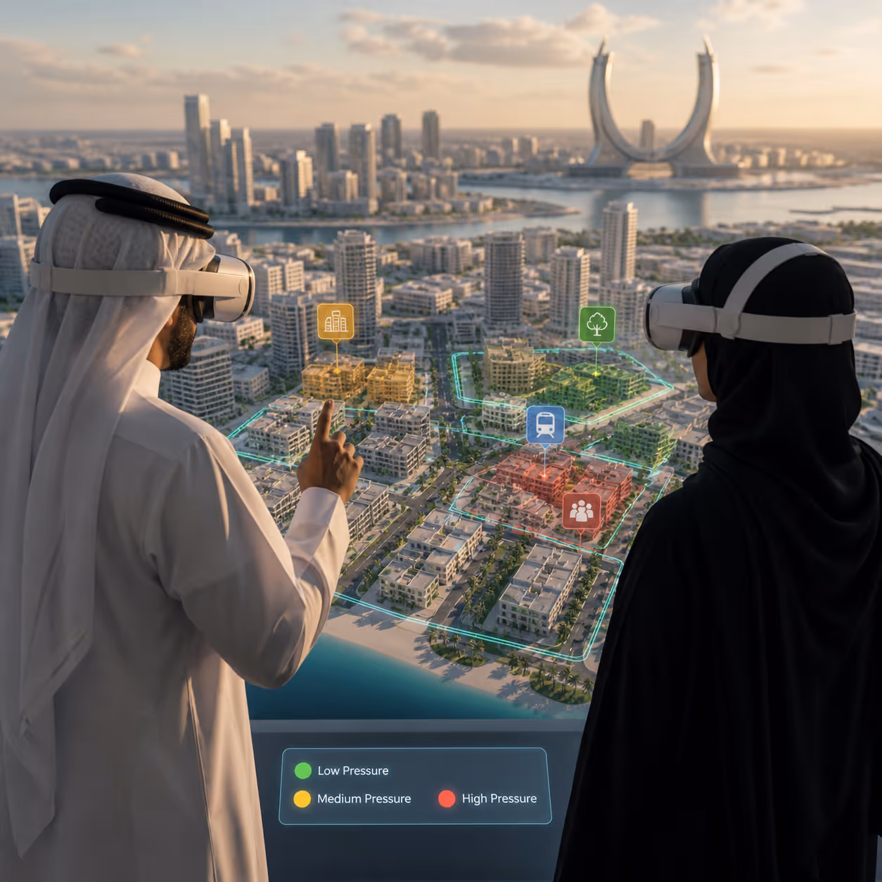
Explainable Urban Pressure Analytics
MEDEEN-XR includes a pressure scoring methodology designed to measure urban pressure at zone level using multiple indicators, including population density, land-use intensity, traffic load, service deficit, environmental stress, green area ratio, and proximity to services.
Bilingual Planning Interface
MEDEEN-XR is designed with a bilingual Arabic and English user interface, helping local and international stakeholders engage with the same planning environment.
Beyond Static Planning Tools
MEDEEN-XR moves urban planning from static documentation into interactive, explainable, and scenario-based spatial decision-making.
Immersive Walkthroughs of Urban Districts
Stakeholders can explore the pilot district through an interactive 3D environment, helping them understand scale, movement, building relationships, open spaces, and public realm conditions more intuitively than through 2D plans alone.
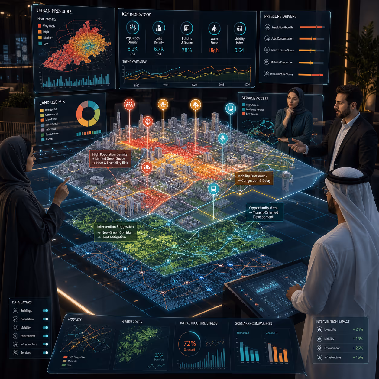
Data-Driven Decision Support
The platform connects spatial datasets, planning indicators, and urban pressure analytics into a visual interface. Instead of only showing what exists, MEDEEN-XR helps explain where pressure is building, why it matters, and what interventions may be needed.
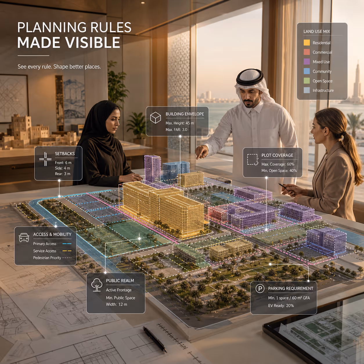
Planning Rules Made Visible
MEDEEN-XR can support the interpretation of planning controls such as land-use types, setbacks, plot coverage, building envelopes, access, parking, and public realm relationships.
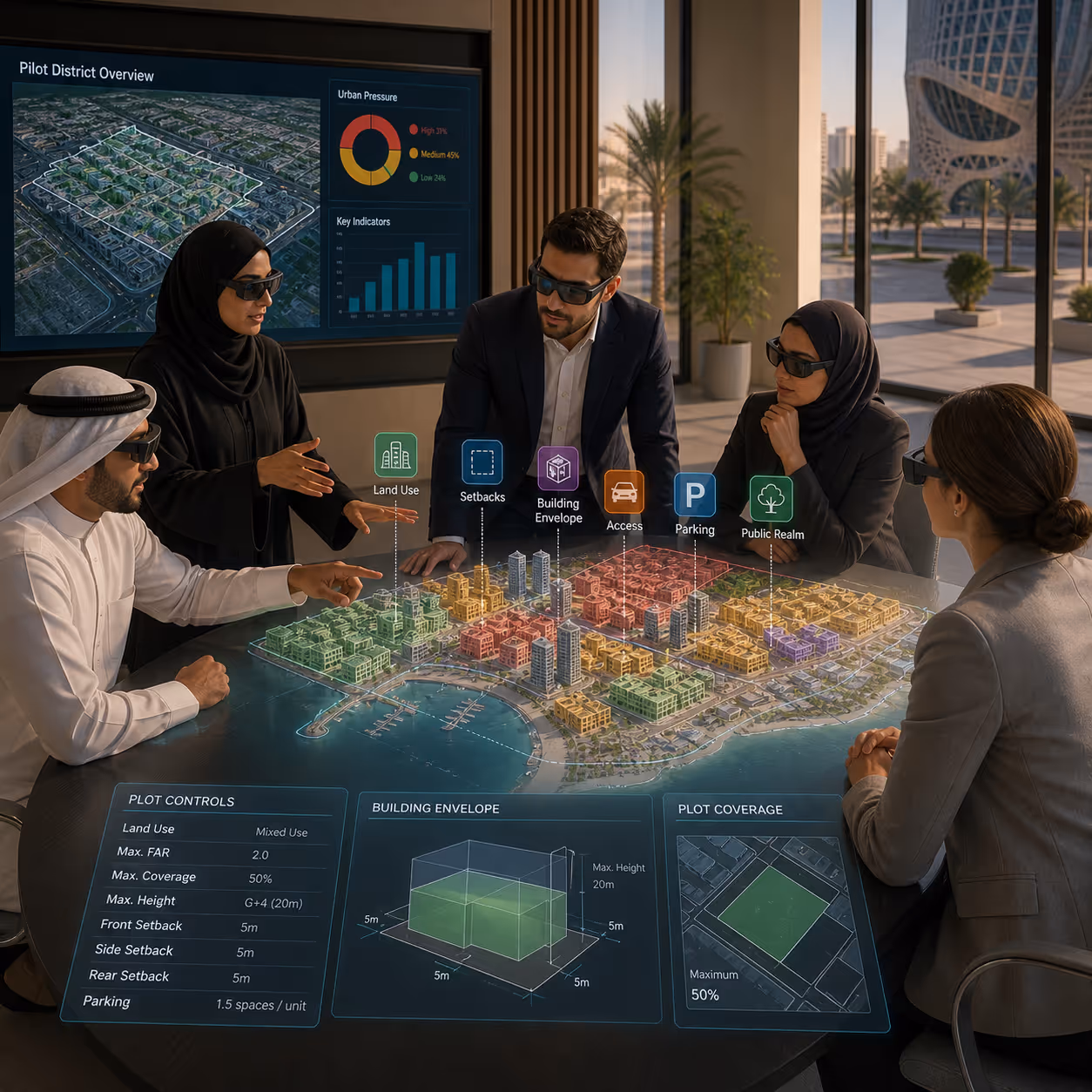
Collaborative Review and Public Engagement
MEDEEN-XR gives planners, government agencies, developers, and citizens a shared visual reference point. This helps reduce misunderstanding, improve feedback quality, and support more transparent planning conversations.
Key Features
Streamable 3D Spatial Pipeline
Converts captured or sourced spatial data into streamable 3D content that can be loaded into a prototype planning application.
Qatar-Hosted 3D Base Environment
Provides a locally hosted spatial foundation for the pilot area, supporting interactive walkthroughs and repeatable alignment across sessions.
Scenario-Based Planning Overlays
Allows users to compare planning scenarios through overlays, making it easier to visualize alternative development options, density changes, service gaps, environmental pressures, and mitigation strategies.
Urban Pressure Score
Uses a composite index to classify zones into Low, Medium, or High pressure based on indicators such as density, land-use intensity, traffic, service deficit, environmental stress, green area ratio, and proximity to services.
Explainable Zone Insights
Each zone can generate clear explanations showing the main drivers of pressure, supporting factors, and planning implications. This helps turn analytics into practical planning guidance.
Arabic + English Interface
Provides bilingual access for local and international stakeholders, supporting clearer communication across Qatar’s planning, development, and innovation ecosystem.
Pilot Testing and Feasibility Validation
MEDEEN-XR’s Phase I roadmap includes pilot demonstration sessions with more than 20 participants and a final feasibility validation report documenting results, TRL4 conclusions, and a Phase II scaling roadmap.
Built for Qatar’s Urban Future
Qatar’s urban development requires planning tools that are visual, data-driven, collaborative, and locally relevant. MEDEEN-XR is designed to support this transition by combining XR, 3D spatial streaming, planning overlays, bilingual interfaces, and explainable analytics into one prototype environment.
Sustainable Development Goals
MEDEEN-XR supports more transparent, inclusive, and data-driven urban planning by helping stakeholders visualize development scenarios, interpret urban pressure, and evaluate planning decisions in a shared spatial environment.

Supported by
MEDEEN-XR is being developed with support from QRDI as part of a Phase I technology development and feasibility validation effort focused on immersive urban planning, spatial data pipelines, Qatar-hosted 3D environments, bilingual interfaces, and scenario-based planning visualization.


Pilot Partners Wanted
We are seeking forward-thinking public agencies, planning authorities, urban development teams, universities, and innovation partners in Qatar to help test MEDEEN-XR in real planning and stakeholder engagement contexts.